
It goes without saying that any fires can be dangerous, yet a wildfire not only ruins lives but at its worst, it can wipe out entire forests—destroying everything in its path and land which people depend their livelihoods on. A wildfire is an uncontrolled fire occurring usually in wildland/open areas, but which can also consume houses or agricultural resources. A wildfire may also be known as a wildland fire, forest fire, vegetation fire, grass fire, peat fire, bushfire, or a hill fire.
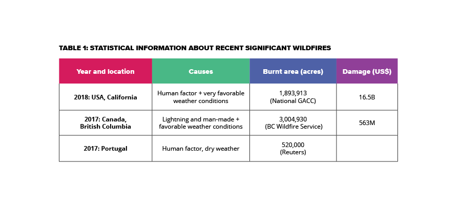
According to National Geographic, wildfire moves at speeds of up to 14 miles an hour (23 kilometers an hour), burning for days or even weeks. On average, more than 100,000 wildfires clear 4-5M acres of land in the US every year. In recent years, wildfires have burned up to 9M acres of land. Table 1 shows stats of some recent wildfires that have occurred worldwide.
Wildfires can be caused by either human error or natural disasters:
Human error is the main cause of wildfires in the US. Many are caused by cigarette butts, campfires left unmonitored, and intentional acts of arson. 90 percent of wildfires in the US are caused by people. Here are a few man-made causes of wildfires:
- Burning debris
- Unattended campfires
- Equipment failure
- Cigarettes
- Fireworks
- Arson
Natural disasters are responsible for the remaining 10 percent of wildfires in the US:
- Lightening
- Volcanic eruption
Solutions evaluation
Cutting-edge technology, such as high-quality aerial imagery from satellites and aircraft, artificial intelligence (AI), and computer vision can be used to understanding and detect wildfire risk. Here are some solutions for early detection of wildfires:
Terrestrial (ground) visual systems
These systems monitor smoke and fire presence using the visible light spectrum. This could include using surveillance, often “tower-mounted” systems, that have the advantage of operating continuously, relatively close to the fire source. Several fire features, such as color, temporal, and smoke patterns are used to detect and locate fire in video data. Because of their proximity placement, they can support ongoing operations even after the fire is initially detected.
Terrestrial (ground) non-visual systems
Non-visual sensing systems are very similar to many of the features of fire monitors employing visible light as noted in the above example. Non-visual systems use infrared light to sense the presence of fire. The key advantage is that the heat and fire can be sensed in occluded conditions (e.g. through smoke, fog, or heavy rain)— which can cause issues for some visual-light spectrum monitors. Conversely, non-visual systems will not detect smoke itself, which can mean a delay in fire detection until an open flame is produced.
Manned and unmanned aircraft
Manned and unmanned aircraft can act as extremely flexible fire detection tools and can quickly move to affected areas. They also have the advantage of potentially spotting fires within larger areas, if they’re capable of higher altitudes. Here is an example of how drones were used to fight wildfires in California recently.
Although special equipment is typically used to detect and document fire locations, even “lower tech” versions, using human spotters and radio transmission, can be quite helpful once a fire has been detected. Limitations of aircraft can include a relatively high cost to deploy as pre-fire detection, since ongoing operation is high (fuel costs, pilot hiring cost, and more).
If an area has a high elevation and is prone to low clouds, visibility can be an issue. Depending on the pilot’s navigational resources and skills, fire detection in specific areas can be a problem if an inconsistent or inaccurate search pattern is used—a fire inception event could easily be missed.
Satellites
Earth-orbiting satellite systems have large area coverage capabilities and can monitor on a 24-hour basis with little operational limitation. However, depending on the type of technology, they may have difficulty in spotting fires if weather conditions are cloudy.
Obviously, the cost to deploy a satellite is high and the usage has to be shared with other critical functions, such as weather detection. With advanced technology, it is possible to have satellites with a high resolution.
Due to orbital limitations, such as only being able to pass by a fire every four or more hours, many satellites cannot provide continuous views of a fire. Satellite operation and data interpretation also require highly trained personnel.
Conclusion
There is a number of programs aimed to educate communities and authorities about fire presentation. However, despite efforts of fire prevention campaigns, wildfires continue to increase in duration, intensity and frequency worldwide. It is evident that without proper preventative measures in place, wildfires will continue to increase. The key aspect is that weather cannot be controlled, but fire prevention systems and technology can help to remove the fuel. Fire experts use wildfire prediction tools which look at the wind speeds, slopes, the fire's direction, and fuel to work out how to extinguish the fire. Using cutting-edge technology, fire experts can predict when a heatwave may happen (because dry weather accelerates fires) and have enough time to advise local authorizes to remove anything that can fuel fire.
SoftServe’s R&D team has been working on the solution, which can bring the difference to this hot topic.